03 December 2016
Quakelapse ~ Decade of Tectonic Data Worldmap
NOAA's worldmap of global earthquakes timelapse of decade... You can view (and interact with) this mapped onto an Earth globe at Science on a Sphere!
02 December 2016
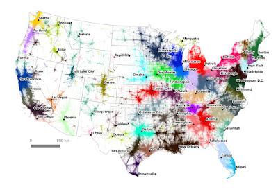
Mega Commutes ~ US Regional Movements...
Data from 130 million commuters reveal US ‘megaregions’... 


"Previously megaregions have been typically identified by an interpretative method that links large metropolitan regions through similar environmental and infrastructure systems, economic links and cultural similarities. These approaches are often based on a ‘best guess’ kind of approach, and do not rely on the analysis of large datasets. Now Dr Alasdair Rae and his co-author Dr Garrett Nelson have developed an empirical approach to identify megaregions using a dataset of more than 4 million ‘commuter flows’ involving the travel to work patterns of 130 million Americans."


Metro Voting ~ Patterns of American Electorate...
In Mapping How America's Metro Areas Voted, Richard Florida writes...
"The geography of the 2016 election is spiky."
Subscribe to:
Posts (Atom)


