
Math Puzzle: A puzzling picture
2 days ago
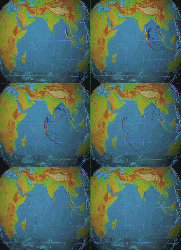
"An earthquake will destroy a sizable portion of the coastal Northwest. The question is when. [...] At approximately nine o’ clock at night on January 26, 1700, a magnitude-9.0 earthquake struck the Pacific Northwest, causing sudden land subsidence, drowning coastal forests, and, out in the ocean, lifting up a wave half the length of a continent. It took roughly fifteen minutes for the Eastern half of that wave to strike the Northwest coast. It took ten hours for the other half to cross the ocean. [...] We now know that the Pacific Northwest has experienced forty-one subduction-zone earthquakes in the past ten thousand years. If you divide ten thousand by forty-one, you get two hundred and forty-three, which is Cascadia’s recurrence interval: the average amount of time that elapses between earthquakes. That timespan is dangerous both because it is too long -- long enough for us to unwittingly build an entire civilization on top of our continent’s worst fault line -- and because it is not long enough. Counting from the earthquake of 1700, we are now three hundred and fifteen years into a two-hundred-and-forty-three-year cycle."Here's a simulation of what happened back in 1700... And here's a geologist's discussion... Finally, documentary shock & awe imagery... NYTimes' DotEarthling Andrew Revkin weighs in too, with nice infographic showing past 8.0 and 9.0 events over 10K years...

 Second, look at this seismographic plot from around the world showing the Earth literally ringing from the rupture of the Sunda megathrust off the coast of Sumatra, Indonesia...
 Given the great work here at MIT Civic Media by Jeffrey Warren and colleagues on Grassroots Mapping and the recent C3 Technologies acquisition by Apple, I was fascinated to run across more about Kite Aerial Photography and especially the backstory to this amazing San Francisco in Ruins photograph from 1906 taken by George Lawrence with a kite-borne camera -- a.k.a. his "captive airship". Simon Baker writes about this history and about the less well-known parts of the story!
 Twitter outpaced geological vibrations during recent VA 'quake!
 "Inspired by XKCD, [here's a] heat map of the frequency of tweets mentioning the word "earthquake" in the 5 minutes after the Virginia earthquake on 08/23/2011. The locations are self-reported by Twitter users and may be erroneous. The spread of the earthquake is approximated to be 4000 m/s."And see here actual seismometrics across the US...

 P.S. Growing up in Silly Valley, CA I feared the Big One (that's still to come). Living here in the Hub of the Universe, I'm now far more afraid of the Category 5 hurricane that's going to barrel up the East Coast, probably this season...
 This ocean floor is fundamentally composed of tectonic plates, which sometimes make sudden moves...
  The water's not uniform, of course, and has different temperatures and flows. Here's the summary path of Thermohaline Circulation -- a.k.a. the Great Ocean Conveyor -- with blue representing deep-water currents, red representing surface currents...
  Surface Oceanic Circulation Patterns influence trade and weather alike, with East Coasts tending towards warm ocean currents and West Coasts dominated by cold ocean currents...
  Sea Surface Temperatures (SST) in normal years shows cold water upwelling in the boxed areas, a source of nutrients which enables rich coastal fisheries...
 But this February 2010 image shows an El Niño year where coastal upwelling slows considerably -- note here off Peru -- meaning nutrient flux drops, plankton plummet, and thus fishing yields collapse...
  These surface patterns combine with atmospheric dynamics to source powerful cyclonic Typhoons worldwide...
  Marine species are widely but unevenly distributed around the world’s coastlines...
  The contest over these riches continues, with the Law of the Sea enabling nation-states to claim Exclusive Economic Zones (EEZ) reaching 200 nautical miles (370 kilometers) out from coastline...
 So it should be no surprise there's growing deep-sea fishing on seamounts and ridges including in the high seas...
 And, last but not least, the Ocean's a prime mover of goods for us all!
 Recall that only a few years ago our solar systemic neighbor Jupiter got whacked by the Shoemaker-Levy 9 comet... If that happened again on Earth, we'd have magnitude 10.0-plus shockwaves -- some estimate the Chicxulub asteroid strike in Yucatán being between magnitude 11 and 12.5 (!) -- and most likely megatsunami too, since odds are 7:3 it hits ocean. And if you're especially curious what the damage would be like, go visit the convenient DIY ImpactEarth! simulator...
 Plus learn something about P, S, and Surface wave propagation... Big quakes (like this 2004 Sumatra event) are so powerful their waves travel around the world multiple times as measured by seismic stations at different distances (in degrees) from the epicenter...
  Finally, look at the past century of Great Earthquakes...
 Difficult to see any pattern at all.
 Aftermath on The Big Picture...

 WSJ's survey of coastal damages... Google serves Post-earthquake imagery of Japan...
 And this ABC Before & After visualizer is especially good. Here's NASA Terra satellite's Moderate Resolution Imaging Spectroradiometer (MODIS) image of pre- and post-view of northeastern Japan shows massive flooding along the coast centered on Sendai city...


