
Showing posts with label Reddit. Show all posts
Showing posts with label Reddit. Show all posts
04 January 2019
28 March 2015
16 January 2015
Population Cartogram ~ Proportionate Worldmap!
This Population Cartogram of the World is a cool way to visualize geo-spatially how many people live where... 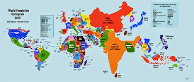

18 January 2014
World Population Density ~ People per Square Km
Lovely hi-res worldmap of people per square kilometer by daysleeperrr posted on Reddit MapPorn. The comments are also illustrative. And author's note... 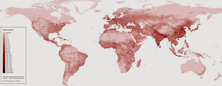
"Took about four hours, with notepad to write the map generator script and photoshop for the legend. I downloaded an .asc (ascii) file [with pop density, about] 30 million records. Converted the huge 200 MB file to a smaller file with this php script in which 30 catogories were used instead of exact numbers. [...] Convert the file to an image. For that I used the PHP GD Library [and script. And finally] Added the legend and some color using photoshop. It's the first time I tried creating a map using programming language only, instead of ArcGIS or tools like that. I was surprised how little lines of code were needed in order to generate such a map. If someone has suggestions for improvement let me know ;-)"

16 January 2014
World Colonization ~ Timelapse Map 1492-2008
Reddit MapPorn offers up simple timelapse mapscape of World Colonization from 1492-2008...  Doesn't include adequate coverage of Chinese empires or Mongol or any of the Native American or African, alas.
Doesn't include adequate coverage of Chinese empires or Mongol or any of the Native American or African, alas.
15 January 2014
Economic Freedom ~ Heritage's 2014 Index Map
Reddit MapPorn spots Heritage's Economic Freedom 2014 map... 
13 July 2011
Manhattan’s Grid ~ Randel 1811 vs NYC 2011
Nice little infographic in NYTimes on How Manhattan’s Grid Grew...  Thanks to itsren on Reddit mapporn for the spot!
"In 1811, John Randel created a proposed street grid of Manhattan. Compare his map, along with other historic information, to modern-day Manhattan."
Thanks to itsren on Reddit mapporn for the spot!
Subscribe to:
Posts (Atom)


