Showing posts with label River. Show all posts
Showing posts with label River. Show all posts
30 September 2017
Flood Resiliency ~ Dutch Lessons for World Cities
Rising sea levels generally and ocean storm surges, river floodwaters, and intense rainfalls particularly inspire new kinds of thinking about water management, going beyond higher dikes and barriers towards more defense-in-depth, including flood-friendly construction, making room for the rivers, and building absorbent greener cities. Here are some good surveys of this movement...

22 October 2016
22 December 2014
Liquid Rainbow ~ Colombia's Vibrant River!
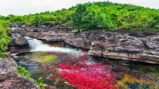
The BBC's Karen Catchpole writes of central Colombia’s 100 Km long Caño Cristales river -- the Liquid Rainbow. Check out photos by Eric Mohl of the river's natural shades of red, blue, yellow, orange and green due to the many hues of the Macarenia Clavigera plant! 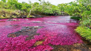

26 October 2013
Lost Rivers ~ Rediscovering Urban Waterways!
Thanks to Jason King at LandscapeUrbanism for spotting the trailer for Lost Rivers documentary by Caroline Bâcle and Katarina Soukup...
"Once upon a time, in almost every city, many rivers flowed. Why did they disappear? How? And could we see them again? This documentary tries to find answers by meeting visionary urban thinkers, activists and artists from around the world."
08 August 2013
Biophilic Singapore ~ Beatley & Newman Spotlight
Biophilic Cities project spotlights city-in-a-garden Singapore... Especially check out their Park Connector Network... I'm also impressed with the dual park+infrastructure waterway greening of Kallang River at Bishan-Ang Mo Kio Park...
  This reminds me of efforts in Los Angeles to revitalize and restore the LA River, Madrid's opening of their Rio, the Room for the River efforts in Netherlands and Europe, and most especially the Daylighting of Seoul's Cheonggyecheon.
I'm also impressed with the dual park+infrastructure waterway greening of Kallang River at Bishan-Ang Mo Kio Park... This reminds me of efforts in Los Angeles to revitalize and restore the LA River, Madrid's opening of their Rio, the Room for the River efforts in Netherlands and Europe, and most especially the Daylighting of Seoul's Cheonggyecheon.
25 May 2013
River Walk ~ San Antonio's Delight-by-Design!
Hearing about the flooding in San Antonio over the last couple days reminded me of their lovely man-made River Walk...
"The San Antonio River Walk (also known as Paseo del Río) is a network of walkways along the banks of the San Antonio River, one story beneath the streets of Downtown San Antonio, Texas, USA. Lined by bars, shops and restaurants, the River Walk is an important part of the city's urban fabric and a tourist attraction in its own right. Today, the River Walk is an enormously successful special-case pedestrian street, one level down from the automobile street."
04 May 2013
LA River Plan ~ Less Concrete, Restored Nature...
Lamar Anderson writes in Atlantic/Architizer that LA Wants to Turn Its Concrete 'River' Into a Real River... 

"Though the waterway hasn’t really been a natural habitat since the 1930s (when the city lined the riverbed with concrete to control flooding), new bike paths, public art, and kayak tours now draw Angelenos to the water’s edge. [...] The Los Angeles River Revitalization Plan, completed in 2007 by the landscape design firm Mia Lehrer + Associates, calls for the removal of most of the concrete and natural habitat restoration around the river."
23 February 2013
Room For The River ~ NL Protective Waterworks
Room For The River is Dutch initiative to avoid high-water flood calamities with layered defense and protective measures.
16 December 2012
Reclaiming Rivers ~ Exploring SP's Dirty Waters

"The Tietê and Pinheiros Rivers, which cut through this metropolis of 20 million, flow well enough in some parts. But in certain stretches, they ooze. Their waters are best described, perhaps, as ashen gray. Their aroma, reminiscent of rotten eggs, can induce nausea in passers-by. José Leonídio Rosendo dos Santos has been diving into both rivers for more than 20 years. Hired largely to unclog drainage gates, he scours the murky depths of the Tietê and Pinheiros, which have symbolized São Paulo’s environmental degradation for decades, bringing to the surface a list of items that is eerie and bizarre. [...] Part of the fascination with Mr. dos Santos has to do with how Paulistanos view their rivers. [...] it was adored by city residents as recently as the middle of the last century, when they fished, swam and held rowing competitions in its waters. Then São Paulo rapidly expanded to become one of the world’s largest cities, its residents moving into high-rise buildings, gated enclaves and sprawling slums. Factories deposited their waste in the rivers. Flourishing districts in São Paulo’s metropolitan area expanded without basic sanitation systems, discharging sewage directly into the Tietê and Pinheiros. The rivers now persist in Brazil’s popular culture as dystopian objects of derision. [... Still there is] hope that the stubborn presence of life along São Paulo’s rivers might reflect the latest phase in their existence: the attempts to resurrect them. Since 1992, the authorities have been advancing with a painstakingly slow project to clean up the Tietê and Pinheiros."See also a piece from the Economist on Cleaning up an urban sewer.
13 February 2012
Esplanade 2020 ~ Boston's Charles River Future!
 Excellent to see Boston's Esplanade Association release their Esplanade 2020 report...
 "To forge a shared vision for the park’s future -- one rooted in its nineteenth century origins, but looking forward to address the needs of the broad contemporary public."


02 May 2008
Planning Harvard ~ From 2020 to 2050 & Beyond

 Given our interest at the Institute in thinking about what MIT 2020 might look like -- or rather, ought to be like -- it's good to see what our wealthy up-river "rival" has formally proposed to the powers-that-be in Boston. In the multi-decade master plan framework for Allston, Harvard University proposes a sustainable, interdisciplinary campus. The overview rendering of Harvard in 2050 has several compelling features, including tunneling the riverside roadways thus creating true pedestrian parks along the Charles. That's what we need in front of MIT -- to create Memorial Park by depressing Mem Drive underneath! Our own Little Big-Dig, only much cheaper and more effective!
Subscribe to:
Posts (Atom)


.svg.png)


